
Models often explain a prediction by listing everything visible, but a mentioned clue is not necessarily an influential clue. To discover what actually drives the answer, remove or isolate evidence in controlled variants and compare how the candidate set changes.
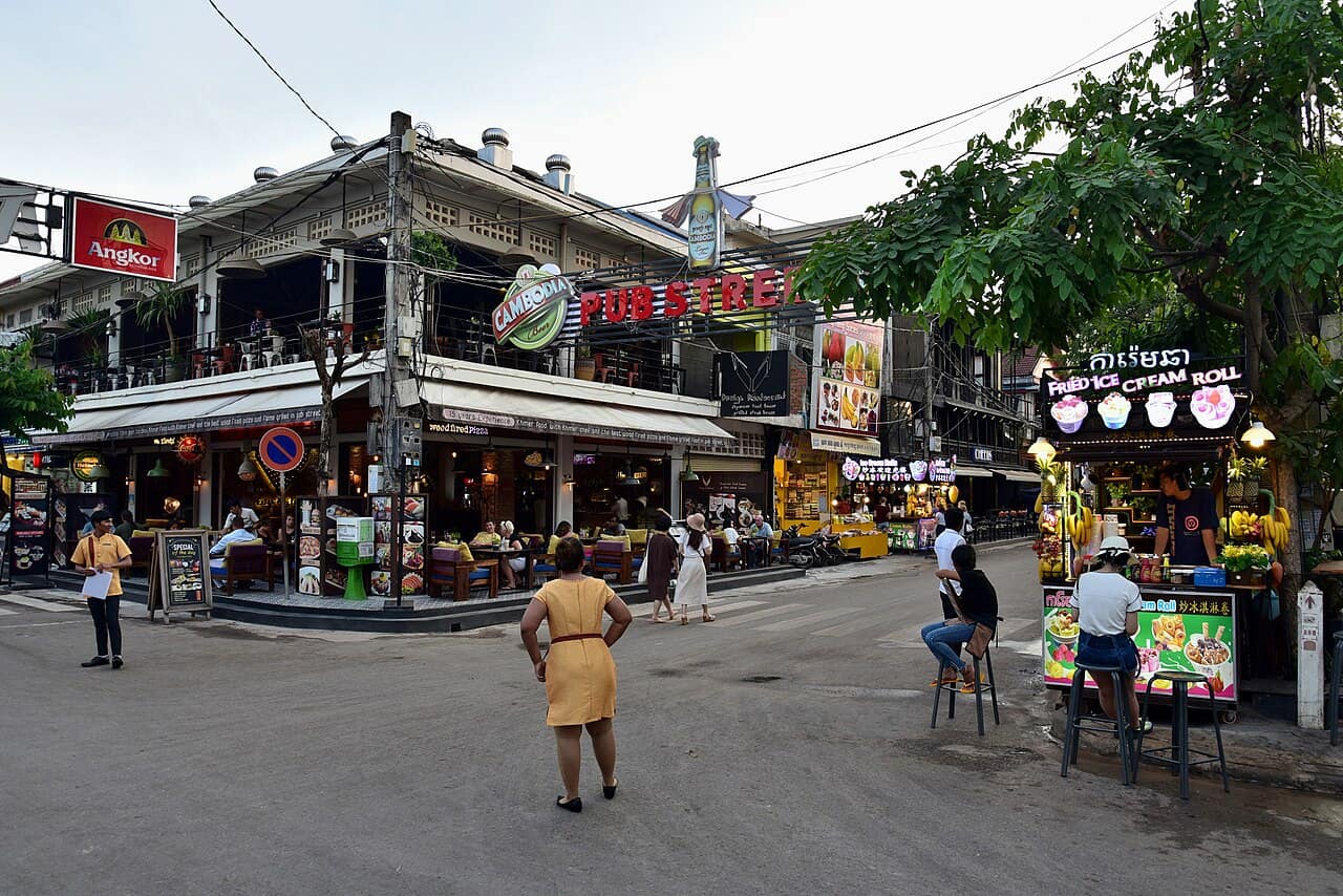
Baseline observations
The full image contains Khmer script, Cambodia and Angkor beer branding, a large Pub Street sign, World Lounge Pizza, Cambodian BBQ, tropical vegetation and a narrow restaurant street. Together these support Cambodia strongly and Siem Reap as a promising city. Individually, they have very different evidential value.
| Variant | Evidence retained | Expected diagnostic value |
|---|---|---|
| Text only | Khmer, Cambodia, Angkor, Pub Street, business names | Measures OCR and name association |
| Country text removed | Architecture, businesses, road and vegetation | Tests whether Cambodia survives without explicit labels |
| Pub Street removed | National clues and two business names | Tests dependence on the famous district name |
| Built environment only | Façades, street width, intersection, wires | Tests regional visual priors |
| Geometry only | Relative order of mapped businesses and road | Tests exact-location verification |
What each clue can really support
Khmer script is the best country discriminator in this image. Cambodia beer confirms the country but is circular if the model merely reads the word. Angkor branding increases the probability of Siem Reap, yet the beer is distributed beyond the city. Pub Street is highly searchable but not globally unique. The two business names are less famous and therefore more useful for exact verification when they appear in the correct order on a map.
Run the experiment correctly
- Save the full-image response as a baseline.
- Make one edit per variant; do not crop, blur and enhance together.
- Use the same prompt, product version and retry rule.
- Record country, city, coordinates, alternatives, confidence and stated clues.
- Measure geographic movement between variants.
- Repeat only according to a pre-declared policy.
If removing Pub Street changes Siem Reap to Phnom Penh while Cambodia remains stable, the image has strong national but weak city evidence. If removing all text sends the answer to Thailand, architecture and street context are not independently supporting Cambodia. If two business-name crops converge on the same block, use that block as a map lead, not final proof.
Influence is not truth
A clue can strongly change a prediction and still be misleading. A tour bus may display its destination; a restaurant may advertise another region; a mirrored image may reverse driving-side evidence. The experiment identifies dependence, not correctness. Every influential clue needs an independent reality check.
Preserve spatial relationships
Aggressive crops destroy object order. In the case image, World Lounge Pizza is near the camera and Cambodian BBQ is farther into the street. Current OpenStreetMap data places them roughly 22 and 57 metres from the published camera point. That ordered relationship is more useful for exact verification than either name alone.
When the result should be downgraded
- Every small crop produces a different country.
- The model cites clues that are not visible.
- Confidence stays high while candidates move hundreds of kilometres.
- The answer collapses when one famous sign is removed.
- The proposed viewpoint cannot reproduce the order of fixed objects.
The final report should identify which clues stabilise country, which stabilise city and which verify camera position. This is more honest—and more useful—than one unexplained confidence score.
Sources
Put the method into practice
When you have a photo to investigate, start with our AI photo location finder and treat its result as a lead to verify, not automatic proof.