
A geolocation model can name the right city and still place its pin on the wrong block. This investigation shows the difference between a useful AI lead and a verified camera position. We begin with a street photograph stripped of its caption and coordinates, record only what can be observed in the pixels, generate competing location hypotheses, search current OpenStreetMap data, and reveal the published ground truth only at the end.
This is a teaching case, not a benchmark of any one model. The photograph comes from Wikimedia Commons, where the photographer later published its coordinates. That gives us an independent answer against which the investigation can be checked. The image was not chosen because it is impossible: it was chosen because the country and city are easier to infer than the exact corner. That gap is where unsupported precision usually enters geolocation work.
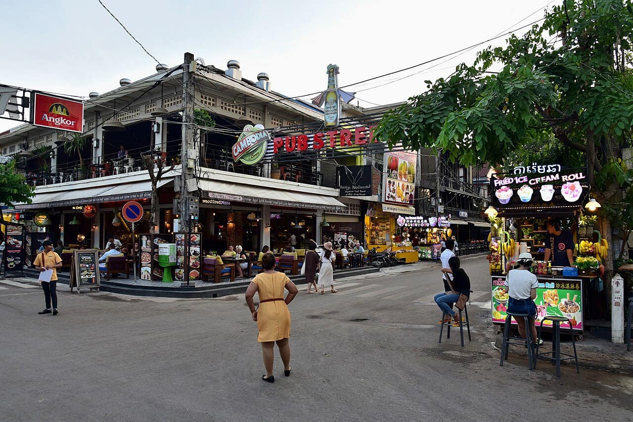
Case setup: separate the test image from its answer
The source page contains a descriptive filename, a caption, GPS coordinates, a capture time and a camera heading. Looking at any of those before the visual pass would contaminate the exercise. We therefore treat the downloaded pixels as the evidence and the Wikimedia page as a sealed answer sheet. In a real investigation, the equivalent step is preserving the original file while working on a copy with filenames, captions and metadata recorded in a separate context column.
The question is deliberately divided into four levels: country, region, city and camera position. Each level requires stronger evidence than the previous one. A Cambodian beer sign may support a country; it cannot by itself support one city. A named entertainment street may support a city; its map marker is not necessarily the place where the photographer stood.
Step 1: inventory the clues before searching
A blind visual pass produced the following inventory. The important discipline is to write down both what a clue supports and what it does not support. This makes it harder to promote a weak association into a fact later.
| Visible clue | What it supports | What it does not prove |
|---|---|---|
| Khmer script on the ice-cream sign | Cambodia is the strongest country hypothesis | A specific Cambodian city |
| “Cambodia” beer branding | Consistent with Cambodia | The brewery name is not a camera location |
| Angkor beer branding | Consistent with a Cambodian tourism district | That the photo is at Angkor Wat or even in Siem Reap |
| Large “PUB STREET” sign | A named nightlife or pedestrian district is searchable | “Pub Street” is not globally unique |
| World Lounge Pizza sign | A potentially mappable business near the camera | The business still exists under the same name |
| Cambodian BBQ sign farther down the street | A second point of interest and an order relationship | Its mapped point is the camera position |
| T-junction-like street geometry | The camera is near an intersection or the end of a block | Road names without a map match |
The country hypothesis is strong because the script and two independent national brands agree. The city hypothesis is weaker. “Angkor” makes Siem Reap plausible, and “Pub Street” is strongly associated with Siem Reap, but both are searchable associations rather than geometric proof. Phnom Penh and another Cambodian tourist centre remain useful control candidates until a mapped feature combination eliminates them.
Step 2: use AI output as a search plan, not an answer
A useful AI response at this stage should not invent coordinates. It should return an evidence ladder: Cambodia at country level; Siem Reap as the primary city lead; “Pub Street” and the two restaurant names as search terms; and Phnom Penh or another Cambodian city as alternatives to reject. The value is not the city name alone. The value is converting pixels into testable queries.
Before opening a map, the working record looked like this:
- High confidence: Cambodia.
- Promising city lead: Siem Reap, because Angkor-related branding and a well-known Pub Street occur together.
- Exact-location requirement: find a street where World Lounge Pizza appears before Cambodian BBQ when viewed into the block, with the same building and intersection geometry.
- Failure condition: if the businesses cannot be mapped or their order conflicts with the photograph, remain at city level.
This is also the natural point to use an AI photo location finder: obtain a structured set of candidates and observed clues, save the complete response, and then leave the prediction interface. Verification must happen against independent sources.
Step 3: a broad map search returns three different kinds of result
On 22 July 2026, a Nominatim query for Pub Street, Siem Reap, Cambodia returned three results rather than one unquestionable coordinate:
- A tourism attraction node named Pub Street at
13.3548263, 103.8547837. - A bar with the Khmer name for Pub Street at
13.3544220, 103.8547698. - The Street 8 road feature, whose international name is Pub Street.
This matters. Search services may return a label point, a business, a road centre or an administrative object. None automatically represents the camera. Treating the first result as the answer would produce a precise-looking pin before the photograph's viewpoint had been tested.
The result is nevertheless an excellent lead: all three objects cluster within the same small entertainment district. We can now search nearby OpenStreetMap features rather than scanning an entire city.
Step 4: convert the photograph into an OpenStreetMap query
The first query should be broad enough to discover naming differences but small enough to avoid drowning in restaurants. A reproducible Overpass query around the Pub Street lead can request named nodes and ways within a limited radius:
[out:json][timeout:25];
(
  node(around:120,13.3548263,103.8547837)["name"];
  way(around:120,13.3548263,103.8547837)["name"];
);
out tags center;
The returned area is densely mapped. Relevant entries include Street 8 with int_name=Pub Street, World Lounge Pizza at 13.3546170, 103.8544516, and a Cambodian BBQ building at approximately 13.3546208, 103.8547726. Current OSM data also contains many restaurants that are not visible in the 2018 photograph, while some visible signs no longer have an obvious current match. That is expected: a map is a changing community database, not a frozen reconstruction of the scene.
The timeout is evidence about the method
During this research session, follow-up requests for all named features around the candidate returned HTTP 504 twice—even after the search radius was reduced from 120 metres to 80 metres. The candidate did not become less plausible because a public Overpass endpoint was busy. The correct response is to preserve the query, retry later or on another public instance, narrow the requested tags, and continue with Nominatim and the standard OSM map.
This is the kind of failure that short geolocation checklists omit. Query complexity, regional map density and public-server load affect what an investigator can retrieve. Tool failure must be recorded separately from hypothesis failure.
Step 5: verify object order and street geometry
The photograph gives more than business names. World Lounge Pizza occupies the near corner on the left. Cambodian BBQ appears farther into the street, behind and to the right of the first building. The street ahead is narrow and functions like an entertainment corridor rather than a marked arterial road.
OpenStreetMap places World Lounge Pizza about 22 metres from the published camera coordinate and the Cambodian BBQ feature about 57 metres away. The difference is not proof by itself, but the order matches the image: the pizza restaurant is near the camera, and the barbecue venue is farther down Street 8. Street 8 is explicitly tagged as Pub Street. A third nearby feature, Red Piano, lies roughly 11 metres from the camera coordinate; its absence from the visible frame is consistent with a viewpoint looking away from that side of the intersection.
The combination is much stronger than any single text match:
- Khmer script and national branding establish the country.
- The named Pub Street establishes a small candidate district.
- World Lounge Pizza and Cambodian BBQ establish two ordered points.
- The narrow Street 8 geometry agrees with the visible corridor.
- The camera must be west of the two mapped businesses, close to the intersection.
A useful negative test is to place the camera at the Pub Street attraction node returned by Nominatim. That point is approximately 61 metres from the published camera position and sits near the middle of the mapped district. It identifies the attraction correctly but does not reproduce the camera viewpoint. We therefore reject it as an exact-photo coordinate while retaining it as a correct district-level result.
Step 6: reveal the ground truth and measure the error
The Wikimedia Commons record identifies the photograph as the corner of Street 11 and Street 08 in Siem Reap, Cambodia. It publishes the camera position as 13.354639, 103.854250, with a capture time of 18:27 on 11 October 2018. The file is credited to Bahnfrend and licensed under CC BY-SA 4.0.
Comparing this reference with the map objects produces a useful precision ladder:
| Candidate or feature | Distance from published camera position | Correct interpretation |
|---|---|---|
| Red Piano | About 11 m | Nearby landmark, not necessarily visible or the camera point |
| World Lounge Pizza | About 22 m | Strong near-camera anchor visible in the image |
| Street 8 feature centre | About 53 m | Correct road, not an exact viewpoint |
| Cambodian BBQ | About 57 m | Correct farther object that helps establish direction |
| Pub Street attraction node | About 61 m | Correct district, wrong exact camera pin |
The investigation succeeds at exact-location level not because one database returned the camera coordinate, but because the independently published camera point explains the ordered arrangement of mapped objects. If the ground-truth record were unavailable, a responsible conclusion would be “the western end of Street 8/Pub Street, near the Street 11 intersection,” not a six-decimal coordinate.
What could have gone wrong?
Brand-name bias: Angkor beer is sold across Cambodia. Jumping from the brand to Siem Reap would be an association, not verification.
Map-marker bias: the first Nominatim result correctly names the attraction but is 61 metres from the camera. A place marker answers “where is this attraction?” rather than “where was this photograph taken?”
Temporal mismatch: the image is from 2018 and the map query was run in 2026. Restaurants change names, move or disappear. Stable road geometry and the relative order of multiple features deserve more weight than one current business listing.
Database completeness: OpenStreetMap is detailed here, but that varies by region. A missing business is not proof that the candidate is wrong. Conversely, a mapped name match is not proof that the photograph shows the same branch.
Tool availability: public Overpass endpoints can time out. Preserve queries and use narrower tags, other endpoints, ordinary OSM browsing or another independent map source.
Metadata leakage: the source filename and Commons caption contain the answer. In any test, keep metadata out of the visual pass and document exactly when it is revealed.
A reusable case-file template
- Preserve: original file, source, acquisition date, dimensions and suspected edits.
- Observe: record pixel-level clues before searching; state what each can and cannot prove.
- Hypothesise: maintain a primary location and at least one alternative.
- Query: save exact search terms, coordinates, radii, tags, timestamps and failures.
- Compare: test object order, distance, orientation and geometry—not visual resemblance alone.
- Reject: explain why plausible candidates fail.
- Conclude: report only the precision supported by independent evidence.
- Audit: reveal ground truth, when available, and calculate distance error.